History
The former name of the district was Giresun or Kiresun. In the Halkapınar area, known as the first settlement site, remnants from the Byzantine period have been identified. Additionally, the castle in Akpınar Village and the bath ruins in Pelitçik Village reflect the historical background of the region. Surface surveys conducted around Halkapınar also revealed ceramic fragments from the Roman period.
Throughout history, the region was under the rule of the Persians, Pergamon Kingdom, Romans, and Byzantines. It was incorporated into Ottoman lands in 1354. During the Ottoman period, the 1530 census registers mention it as “Nahiye-i Kiresin.”
During the Turkish War of Independence, Savaştepe witnessed significant conflicts. On June 29–30, 1920, battles took place between the Kuvay-ı Milliye forces and Greek troops in the district. In memory of this resistance, a Martyrs’ Monument was later built. After these events, the area was named “Savaştepe” (meaning “Battle Hill”) and officially began to be referred to by this name on October 10, 1934. It gained district status in 1954.
Geographical Location and General Information
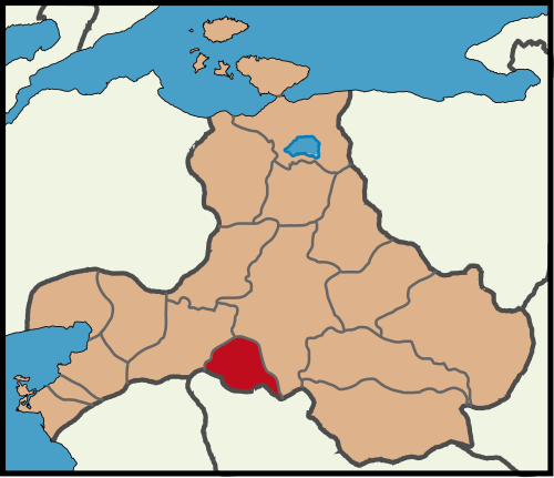
Savaştepe is a district of Balıkesir Province, located in the southern part of the Marmara Region. It is bordered by the central districts of Balıkesir to the northeast and east, Manisa to the south, and İvrindi to the west and northwest. The district terrain is hilly and divided by river valleys, forming a plateau known as Uzuncayayla. The elevation is generally around 315 meters. Some of the district’s streams flow toward the Marmara Sea, while others flow toward the Aegean Sea.
With an area of approximately 427 km², Savaştepe had a population of 16,765 according to 2022 TÜİK data. The district has a climate characterized by hot, dry summers and cold, rainy winters. The vegetation mainly consists of maquis and mixed oak-pine forests.
The Uzuncayayla region is one of the highest points of the district. The small streams originating from the surrounding valleys flow toward both the Marmara and Aegean basins. This geographical feature places Savaştepe within the transition zone of two sea climates.
Economy and Culture
The district’s economy is based on agriculture and livestock. The main agricultural products include wheat, barley, legumes, beet, grapes, tobacco, cotton, sunflower, and sesame. Livestock farming occupies a significant place. In addition, mercury and perlite mineral deposits are found within the district boundaries.
Savaştepe is also known as the location where the Savaştepe Village Institute, an institution that played a significant role in the educational history of the Republic era, was established. This institution contributed greatly to the district’s educational and cultural life and served as an important example in Turkey’s rural development model.
In recent years, small-scale industrial enterprises, dairy product, and olive oil production facilities have developed in the district. Through agricultural cooperatives, local producers are supported, aiming for both economic and social development. Culturally, local festivals, folk dances, and handicraft events enrich the social fabric of Savaştepe.